Trekking in Val d'Elsa: best trails and day routes near Barberino
The Val d’Elsa is one of the best-kept secrets of Tuscan walking. While Cinque Terre is overcrowded and the Dolomites require specialised preparation, the trails here ask only for a pair of decent boots and a few hours of your time. The terrain is rolling rather than alpine, the paths are generally well signed, and the scenery combines vineyard country, medieval villages, wooded ridgelines, and open farmland in proportions that change every few kilometres.
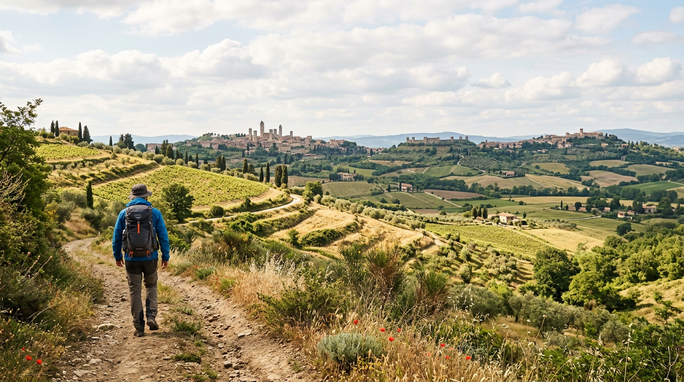
From Barberino Val d’Elsa you can access a large and varied network of walking routes without driving to a trailhead. Some of the best paths begin almost at the edge of the village. Whether you are looking for a two-hour stroll or a full day on the trail, the Val d’Elsa can accommodate you.
Trekking in Val d’Elsa
The walking landscape in the Val d’Elsa divides into three broad types. The valley floor routes follow the Elsa river and the connecting roads between towns, staying relatively flat and passing through agricultural land. The hillside routes climb into the Chianti zone to the east, entering the vineyard and oak woodland country that defines the classic Chianti Classico landscape. And the ridge routes link the old medieval villages on the higher ground, passing through some of the most intact and least-visited agricultural countryside in central Tuscany.
The walking season is long: from March through November you will find conditions suitable for at least part of the day. The ideal months are April, May, September, and October. In spring the light is soft, the flowers are out, and the temperatures are mild enough to walk from morning to evening without difficulty. In autumn the colours shift, the harvest activities fill the farms, and the air smells of pressed wine and woodsmoke.
July and August are hot. Walking at midday in high summer on open terrain is uncomfortable and potentially dangerous. Start early, reach your objective before ten in the morning, and rest through the heat of the afternoon. Even in summer, the shaded forest paths on higher ground are pleasant in the morning hours.
From November onward the clay tracks that are the typical surface of Val d’Elsa paths become sticky and difficult after rain. Waterproof boots are necessary from late autumn through early spring. The routes that follow gravel or stone surfaces remain accessible throughout the year.
Marked trails near Barberino
The trail network in the immediate area around Barberino Val d’Elsa is maintained by a combination of CAI (Club Alpino Italiano) and the local municipal authorities. The routes are waymarked with coloured painted blazes on rocks, trees, and wooden posts.
One of the most rewarding short routes from Barberino goes southeast toward San Donato in Poggio, a distance of about eight kilometres. The path passes through the edges of established vineyards and then through light oak and cypress woodland before arriving at the walls of one of the best-preserved medieval villages in the Chianti. San Donato’s central piazza is tiny and beautiful, and the village bar serves one of the better espressos in the area. The return on the same path adds another eight kilometres for a pleasant 16-kilometre round trip.
A circuit around the Certaldo area, about 12 kilometres from Barberino, takes you through the lower and upper parts of this historically interesting town. Certaldo Alto, the upper medieval brick town, sits on its red clay hill like a fortress. The views from the upper town over the Val d’Elsa are wide and clear.
The route northeast from Barberino toward Tavarnelle Val di Pesa and on to Badia a Passignano passes through the most photogenic part of the Chianti Classico zone. This 12-kilometre trail moves through established vine rows, farm tracks lined with old stone walls, and stands of cypress that seem placed by a landscape architect. The abbey at Badia a Passignano, a still-functioning Vallombrosan monastery surrounded by the vineyards of an important Antinori estate, is a significant destination in its own right.
The Via Francigena on foot
Walking a section of the Via Francigena from Barberino Val d’Elsa is one of the most satisfying ways to engage with the long history of this landscape. The route is one of the great medieval pilgrimage roads of Europe, running from Canterbury in England to Rome, and the Tuscan stretch passes directly through this territory.
The Val d’Elsa section of the Francigena runs between San Gimignano to the northwest and Colle di Val d’Elsa to the south, covering territory that is quiet, beautiful, and well waymarked. San Gimignano is about 15 kilometres from Barberino. Colle di Val d’Elsa is about 15 kilometres in the other direction. This gives you a natural corridor for a day walk of between 25 and 30 kilometres if you walk point to point, or shorter sections if you return to your starting point.
A particularly good option is the section from Colle di Val d’Elsa southward toward Strove, about 10 kilometres, which passes through open Sienese countryside with good views and minimal road walking. This two- to three-hour stretch gives you the character of the Francigena without requiring a full day’s commitment.
The route is waymarked throughout with yellow signs bearing the Canterbury cross logo. GPS tracks can be downloaded free from the official AEVF website. A printed guide adds comfort on any long day.
Routes for all fitness levels
For easy walks requiring no more than one to two hours, the perimeter trail around Barberino Val d’Elsa itself follows the edges of the historic settlement on paths that mix compacted earth, gravel, and stone. This route gives good views over the surrounding countryside and is an excellent orientation walk for the first day of a stay. You finish where you started and arrive back with a much clearer sense of where you are in the landscape.
A moderate half-day walk suited to most fitness levels runs from Barberino to San Donato in Poggio and back, covering about 16 kilometres with modest elevation gain. Allow three to four hours for the round trip including time in the village. This is a route that satisfies without demanding.
For a full day on the trail, the circuit from Barberino north to Tavarnelle, then east to Badia a Passignano, and back by a different path covers 20 to 25 kilometres. The abbey provides a midpoint destination and the route as a whole gives you a comprehensive picture of the Chianti walking landscape.
Experienced walkers looking for more distance or elevation can walk from Barberino eastward toward Greve in Chianti. The distance is approximately 20 kilometres with around 400 metres of cumulative elevation gain. The vineyard landscape intensifies as you move deeper into the Chianti Classico zone, and the town of Greve itself, with its distinctive arcaded main piazza, is a worthwhile destination.
How to prepare for a day of trekking
Footwear is the most important single preparation. Trail shoes with grip and light ankle support are adequate for most Val d’Elsa routes in dry conditions. Full hiking boots are better on longer or rougher circuits in autumn and winter. Avoid flat-soled trainers on any route involving unpaved surfaces.
Carry enough water for the full planned distance. Drinking fountains, called fontanelle, are present in most villages but entirely absent on rural paths. For a full day of five or more hours, plan for two to three litres of water depending on the temperature. In summer carry more.
A paper map or downloaded GPS track is more reliable than mobile data in the Val d’Elsa hills, where signal can be intermittent on forest trails. The Komoot and Wikiloc apps both have good Tuscan trail coverage. The CAI and regional trail authorities publish free GPX files for many of the marked routes.
Sun protection matters from April through September. On open vineyard terrain there is often no shade for long stretches. A hat, sunscreen, and light clothing that covers your arms will make midday walking more comfortable.
Tell someone where you are going before you set out. This is basic trail practice on any route, however straightforward.
Where to stay
Sogno d’Oro in Barberino Val d’Elsa is ideally positioned for walking in the Val d’Elsa. The trail network begins close to the guesthouse and extends in multiple directions depending on how far you want to go.
Spending several days here with a different route each day gives you a textured and personal experience of a landscape that is too rich and varied to understand from a car. The Val d’Elsa on foot is a different place from the Val d’Elsa seen through a windshield.